 Print This Page
|
Print This Page |
Lower Than Normal Dissolved Oxygen Levels Observed
in Maryland's Chesapeake Bay (Updated 4/8/04)
Resource Assessment Service scientists identified record low monthly bottom dissolved oxygen levels for March 2004 in portions of the Chesapeake Bay and some key tributaries monitored in the Department’s Chesapeake Bay Monitoring Program. These data have been collected monthly since 1985. The low oxygen levels in March 2004 were observed in 13 of 57 sites, generally in the lower, tidal portions of most river sites south of the Chesapeake Bay Bridge. Record low monthly dissolved oxygen levels were also observed 9 times during both January and February 2004 (Figure 1).
Figure 1.
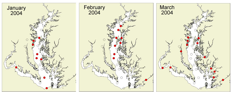
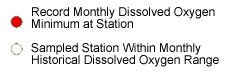
Six stations in March 2004 were below a dissolved oxygen threshold of 5.0 mg/l. Oxygen levels below 5.0 mg/l can cause stress to living organisms, and reduce available habitat for Bay organisms. (For more information on dissolved oxygen criteria for Bay organisms, visit the EPA Chesapeake Bay Program). Low dissolved oxygen levels of this magnitude during March have not been observed since the inception of the Chesapeake Bay Monitoring program in 1985, but similar trends in lower dissolved oxygen centering around the Chesapeake Bay Bridge area have been observed previously, such as in March 2000 (Figure 2). The majority of stations from March 2000 and 2004 are still in an extremely healthy range of greater than 7.5 mg/l of dissolved oxygen.
Figure 2.
Scientists in the Maryland DNR Resource Assessment Service are examining potential causes for these extreme observations, including:
Scientists will continue to review all available water quality data to evaluate dissolved oxygen and nutrient conditions in the Bay and its tributaries throughout the spring and results will be updated to the Department’s Eyes on the Bay website. March 2004 nutrient data for all monitored stations will be available soon, and will be included in these analyses. With an increase in our continuous monitoring sites (from 24 stations in 2003 to 34 stations in 2004), and water quality mapping coverage (13 tributaries) for 2004, DNR will be even better equipped to track low dissolved oxygen events, monitor overall water quality, and assess valuable living resources habitat in the Chesapeake and Coastal Bays.