 Print This Page
|
Print This Page |
Impact of Tropical Storm Ernesto and subsequent rain event (September 2006)
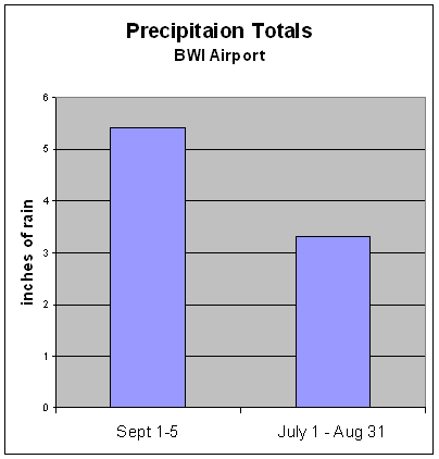
The remnants of Tropical Storm Ernesto put an end to the two months of drought conditions since the deluge at the end of June. Ernesto was followed by a low-pressure system off of the Atlantic Coast which added even more rain to the weekend total. Precipitation data from BWI airport showed that 5.41 inches of rain fell between September 1 – 5, 2006 . This is more rain than the 3.31 inches recorded in the previous two months of July and August. Ernesto dumped even more rain on the lower Eastern Shore of Maryland, as 7.47 inches of rain was recorded at Salisbury , MD during the first five days of September.
 |
 |
|
|---|---|---|
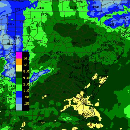
source: www.intellicast.com |
Stream discharge data from the USGS shows that some stream flows on the Eastern Shore were an order of magnitude greater than their historic daily median.
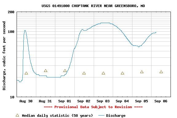
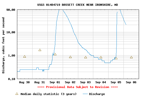
Source: USGS Real-Time Water Data for Maryland ; http://waterdata.usgs.gov/md/nwis/rt
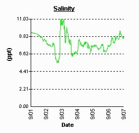
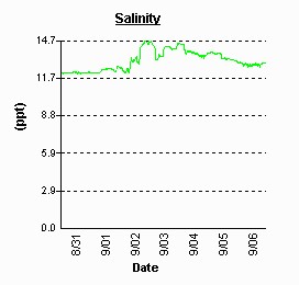
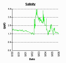
With such a significant rainfall in a short period of time, water quality in and around the Chesapeake Bay was greatly affected. Stations near the main stem of the bay recorded an increase of salinity resulting from a moderate storm surge moving up the bay. This occurs when the low pressure storm “pulls” saltier water up the bay. NOAA wind sensors on Thomas Point Lighthouse logged sustained Northeast winds of 45 mph late on 9/1 and overnight into the early morning of 9/2. These strong Northeast winds also move water up the bay by a phenomenon known as Ekman Pumping.
(see: http://amsglossary.allenpress.com/glossary/search?p=1&query=ekman+pumping&submit=Search )
Below are three graphs from Continuous Monitoring stations which show the effect of the storm surge as it relates to salinity levels.
| Sandy Point – South Beach | Eastern Bay – Ches. Bay Environmental Center | Sassafras River – Betterton Beach |
|---|---|---|
 |
 |
 |
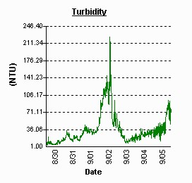
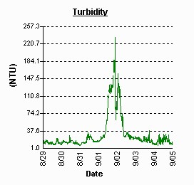
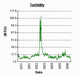
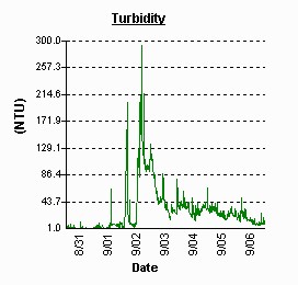
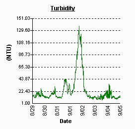
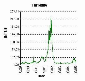
Another effect of the storm was an influx of suspended solids carried into the bay by stormwater runoff. This is evident by the detection of turbidity spikes during the rain event, as captured by several Continuous Monitoring stations. The graphs below show the extremely sudden and dramatic increase of turbidity at stations on Eastern Bay and the Sassafras, Potomac and Choptank Rivers .
| Eastern Bay – Kent Point | Sassafras River – Betterton Beach | |
|---|---|---|
 |
 |
|
| Potomac River - Swan Point | Potomac River – Fenwick Shores | |
 |
 |
|
| Choptank River – Jamaica Point | Choptank River – Horn Point Lab | |
 |
 |
What can I do to lessen impacts on the Bay?
Storm events of this magnitude provide another reminder of the impact that impervious surfaces such as roads, rooftops and parking lots have on the natural landscape. Maryland's Tributary Strategies Program provides management opportunities to review and revise codes and ordinances to minimize the amount of hard surfaces added to the landscape through development. Homeowners should evaluate their properties and reduce the amount of runoff by adding rain barrels, installing rain gardens to capture runoff, plant trees, and disconnect downspouts to storm drains and roadways to release storm water runoff over lawns or unpaved areas instead. Alternative paving approaches for sidewalks and driveways reduce the amount of run-off and allow rainwater to soak into the ground.
Sources of information:
Water quality data, Maryland DNR website: www.eyesonthebay.net .