Attribute_Accuracy_Report:
MD DNR followed specific procedures to ensure that the Vertical Water Quality Profiler Project design was properly implemented and managed with sufficient accuracy, precision, and detection limits. Accuracy (closeness to the true value) of collected data was controlled and assured by the proper use, calibration and maintenance of field equipment for the measurement of physical and chemical parameters.
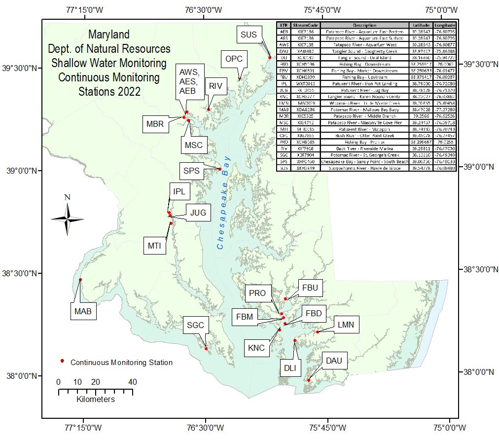
The vertical profiler system consisted of a YSI 6951 pontoon platform fitted with a YSI 6960 Controller Assembly and a YSI 6955 Winch Assembly. A YSI 6600V2-4 monitoring sonde was suspended from the vertical profiler to measure water quality.
The YSI 6600V2-4 sonde was configured with the following probes: 6560(conductivity/temperature); 6561(bulb pH) or 6579(tall pH) or 5091(flat pH); 6136(turbidity); 6150ROX (dissolved oxygen); 6025(fluorescence/chlorophyll).
Resolution, range and accuracy specifications for the sonde and probes may be obtained from the manufacturer. [<
https://www.ysi.com/products/multiparameter-sondes>]
Procedures used to control and assure the accuracy of field measurements consisted of equipment maintenance, calibration of field instruments, and verification of calibrations. In Fishing Bay, challenging environmental conditions (e.g. strong tidal currents) and mechanical failures resulted in the following equipment adjustments and/or repairs: rewiring the sonde cable connections (May 23), increasing the weight of the sonde by adding weight to the sonde probe guard (July 7, August 18), replacing the winch/reel assembly (June 8, November 3), installing a new sonde cable (November 3), installing a new battery (July 27, November 3, November 21), pumping water out of a partially flooded pontoon (November 21), and installing a new solar panel (November 21).
Details of how data acquired with YSI sondes were quality assured and quality controlled may be found in the process description elements in the Lineage portion of this metadata record.
The Fishing Bay vertical profiler was set to conduct profiles every hour beginning at the top of the hour. Profiles were conducted in a "bottom up" manner, with the first reading for each profile taken approximately 1 meter above the bay bottom. As the instrument rose through the water column, additional readings were taken at 0.5m-1.0m increments. The profiler moved to a new depth about every 2 minutes and a complete profile took approximately 8 minutes to complete.
At initial deployment on April 25, the vertical profiler experienced mechanical problems and was unable to conduct profiles. As a result, the sonde was deployed at a fixed depth approximately 1 foot off the bay bottom and programmed to collect readings every 15 minutes. On May 11, the data sonde was replaced and normal profile operation and data collection began.
The vertical profiler in Fishing Bay was initially programmed to collect readings at 4.0m, 3.0m, 2.0m, 1.0m, and 0.5m. Early site visits determined that the total water depth at the monitoring site was often 4.5m or less. For this reason, on June 8 the instrument was reprogrammed to collect the bottom reading at 3.5m depth. Collection of other profile readings remained at 3.0m, 2.0m, 1.0m, and 0.5m depth.
Although the vertical profiler is programmed to collect profile readings at specific water depths, the actual depths for data collection can vary slightly due to wave action and water currents displacing the sonde in the water column. This was especially true in Fishing Bay, where strong tidal currents made it difficult for the instrument to reach and maintain the programmed depths. To counteract the effects of water currents on the sonde position, a probe guard with a 4 pound weight attached was added to the sonde on July 7. The additional weight, however, caused battery power to drain more quickly, so the 4 pound weight was replaced with a smaller weight on August 18. With the added weight, the depths at which readings were taken were generally within +/- 0.5m of the programmed depth.
During the routine site visit on October 7, the sonde was not exchanged due to connectivity issues with the replacement sonde.
On November 17, the 3.5m reading was dropped from the profile sequence because of the instrument’s continued difficulty reaching depth in the strong currents. Also on November 17, the depth stabilization time was changed from 60sec to 10sec. Changing the stabilization time allowed the sonde to stabilize, collect a reading, and move to a new depth more quickly, thus preserving battery power.
Reducing the profile sequence to four readings and shortening the depth stabilization time allowed complete profiles to be conducted in less time. After November 17, a full profile sequence was completed in approximately 4mins. Due to the speed at which the instrument was operating, sequential depths in the profile were often sampled within one minute of each other, resulting in the same timestamp being assigned to readings at different depths.
In addition to conducting profiles, the vertical profiler recorded hourly readings at 5 minutes before each hour while the sonde was resting in a parked position. Often, if mechanical issues prevented the instrument from performing profiles, hourly data collection at the parked depth continued, thus creating a more complete data record. Initially, the parked position was set at a depth of 1.0m. On November 17, the parked position was changed to a depth of 3m to better monitor water quality conditions in deeper waters.
On December 25, the vertical profiler was moved off-site without the consent of DNR. Unauthorized person(s) relocated the profiler platform approximately 1.3 nautical miles southeast of the original site (new coordinates: 38.287067, -76.003267). All data collected after December 25 are considered invalid.
At first deployment on April 25, 2022, the vertical profiler was unable to conduct profiles due to mechanical issues. As an alternative setup, the sonde was fixed at a depth approximately 1ft from the bay bottom and configured to collect readings every 15 minutes. Additionally, the sonde was initially calibrated for dissolved oxygen, specific conductance, and temperature only. The instrument operated in this manner -- collecting limited parameters at a fixed depth – until May 1, when an electrical short caused the profiler to stop logging any data. On May 11, the sonde was replaced and regular profile and hourly data collection began.
Overall, data collection by the vertical profiler was inconsistent throughout the 2022 monitoring season. Strong tidal currents at the monitoring site made it difficult for the instrument to stabilize at the depths set for data collection. The strong currents also contributed to operating issues such as tangling of the sonde cable and excessive draining of battery power. The persistent mechanical issues and difficult operating conditions resulted in sporadic operation of the profiler throughout the season, with numerous gaps in the data record as a result. Significant data gaps (greater than 1 day) are detailed in the following paragraphs.
May 15-23 and October 15-20: No profiles were conducted and hourly readings were recorded at a depth of approximately 4m. It is presumed that the sonde was either very near or resting directly on the bay bottom during these times, likely due to the sonde striking the bay bottom during a profile sequence. If the sonde hits bottom (as can happen during extreme low tides or windy conditions), the instrument will switch to "standby" mode and stop conducting profiles. In both instances, normal profile operation resumed following a maintenance visit to the site.
May 25 - June 8: A tangled sonde cable likely caused the vertical profiler to stop conducting profiles. No profile or hourly data were collected during this time.
August 1-18: Data collection (profile and hourly) ceased due to an electronic malfunction within the sonde.
October - November: Sporadic operation of the vertical profiler worsened, and numerous data gaps greater than 1 day occurred during this period. It is suspected that bad weather and decreasing daylight in the autumn months prevented the battery from fully recharging, thus interfering with instrument operation.
Profile data collection ended on December 13. During routine maintenance on December 13, a coupling on the winch reel broke, disabling the instrument for vertical profile operation. Instead, the sonde was set at a fixed depth of 3m and hourly data collection continued at the 3m depth.
Hourly data collection ceased on January 2, 2023. In late December, the profiler platform was moved off-site without the consent of DNR. On January 2, 2023, DNR personnel located the instrument approximately 1.3NM SE of the original site and retrieved the sonde from the instrument. A replacement sonde was not deployed.
On January 5, 2023, the vertical profiler platform was removed from the water to prevent damage from winter ice and to perform annual cleaning and maintenance.
Additional profiles may appear in the data record on dates when DNR field biologists exchanged sondes at the profiler site. During field visits, biologists often triggered a profile to be performed in order to test that the instrument was operating properly. Additional profiles may also appear in the data record when profiles were triggered remotely during troubleshooting exercises.
All other sonde attribute values that are missing from the dataset were censored during the data quality control process. Analysts examined the data and masked values that were determined to be unreliable.