 Print This Page
|
Print This Page |
Investigations of impacts to SAV from June 2006 rains
In late June 2006, the Chesapeake Bay area experienced a massive deluge of rain that had scientists and managers worried about the fate of submerged aquatic vegetation (SAV) beds throughout the region. There was concern that these rains would be a repeat of SAV destruction that was witnessed after Tropical Storm Agnes in 1972. Susquehanna River flows from the June 2006 event were only about one third the proportion of Agnes, although most of the Bay above the Bay Bridge was extremely turbid for several weeks as documented by satellite imagery available on Eyes on the Bay's Eyes in the Sky page (See images for June 28th 2006 and later). USGS monitoring revealed that July Chesapeake Bay flows were the highest on record showing the true carry-over impact of the June rains, but in some regards it was fortunate for the Bay ecosystem that conditions were dry preceding and following the storm.
DNR has been conducting investigations on the possible impacts of these June rains and the following article discusses in detail, observations and pictures made from an aerial overflight on August 16th, ground observations of the Susquehanna Flats SAV beds, and a summary of harmful algal blooms in the Bay for the year. In short our observations indicate that some upper Bay SAV beds have reduced densities from 2005, but on a large scale the impact from the June rains was probably minimal. The aerial overflights still highlighted the fact that most upper Eastern Shore creeks and upper reaches of rivers were laden with sediment that impeded water clarity. Many algal blooms were also observed in various river systems. Ground observations show that densities in the northern Susquehanna flats may be reduced from 2005, but other areas in the flats were at equivalent or greater densities. In the Spring, drought conditions produced few algal blooms and scattered blooms of various assemblages have been observed post-June rains. The August 16 aerial overflight revealed that blooms may be more widespread than is indicated through traditional monitoring programs. At the time of this publication (Friday, August 25th), growing Microcystis blooms are being observed on the Potomac south of Mattawoman Creek.
The map below shows the path of the August 16th overflight. Click the blue dots for aerial photos. Hold the cursor over the dot for photo descriptions. Click elements on the left-hand menu to read detailed SAV observations from the air and on the water. Alternatively, scroll below the map to read the observations.
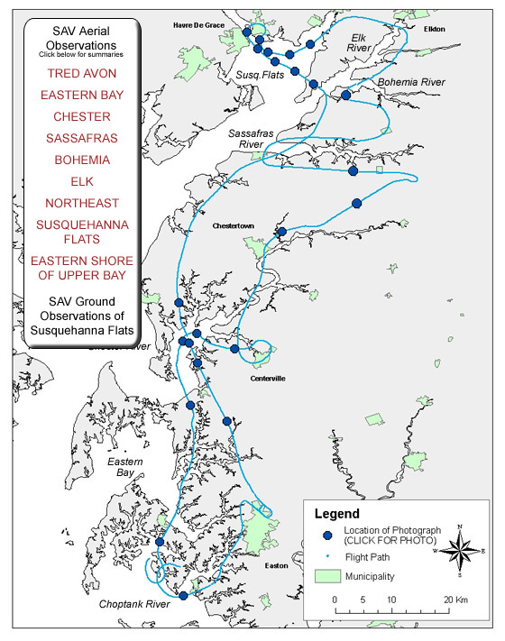
SAV Aerial Observations - August 16, 2006
Tred Avon/ Broad Creek - We flew due west from Easton Airport down Baileys Neck along Trippe Creek. Some small beds along the southern shore were present (Q4, P2) and the large bed at the confluence of Trippe and Goldsbourgh Creek was present and very dense (JB4, LB2). The northern shore beds were very sparse and were not all present. Some beds were present along the outer edge of Platy Cove to just upstream of Town Creek. As we approached the mouth of the Tred Avon and prepared to fly north up Ferry and Deep Neck, bed R2 was absent along with the majority of the beds in the head waters of Irish Creek. Most of the outer beds from Lucy Point to Bridge Creek were present with reduction in density from 2005 photos. The majority of beds along Deep Neck Point and Cedar Point (AC2, HC1, IC2) were absent. There appeared to be no change in beds along Barrett Creek and Cove. Beds along San Domingo Creek were present with some reduction in density.
East side of Eastern Bay � We crossed the Miles River near St. Michaels and flew up the Bennett Point peninsula towards Kent Narrows . Dark mahogany colored stains (algal blooms) were present in the Wye River and the majority of its creeks. Greenwood Creek also appeared to have blooms present. From an oblique angle, a sediment plume was visible off the southern edge of Parsons island. The large, dense sago pondweed beds (north of A1) I had seen earlier in July and August were not visible. Marshy Creek beds appearred dense along the majority of its shoreline with only a slight reduction in bed width near the southern shore. After crossing Route 50, beds along Jackson , Judith and the other unnamed coves east of Kent Narrows held dense beds. During site visits to these creeks in the past few weeks, we have identified large, dense beds of sago, redhead, milfoil and some widgeon grass and elodea present in these areas.
Chester River � We flew over Eastern Neck Island and observed beds present along Hall Creek and Point. The beds in Shipyard Creek were present but appeared sparser than recorded in 2005. The SAV beds in Eastern Neck Narrows appeared greatly reduced with beds CB2, DB3, NB1 nonexistent. The large beds on the main bay side of the narrows were either nonexistent (AC1, BA4, ZB2) or reduced in density (GA4).
We headed east and flew over Grove Creek (similar SAV coverage and density to 2005 survey) and then the Corsica River . The Corsica River had new beds present on the southern edge of Spaniard Point. Besides Middle Quarter Cove (N4)(similar SAV coverage and density to 2005 survey) no other SAV beds were apparent in the Corsica River . Dark mahogany colored stains (algal blooms) were present in the Corsica River and the majority of its creeks.
We continued flying up the Chester to observe the beds upriver from Chestertown. The beds downstream of Morgan Creek were absent (Q1, N2). The low density beds visible between Roundtop and Travilla Wharf in 2005 were still present.
Sassafras River � Most beds on the southern shore of the Sassafrass River appeared to be similar to those recorded in the 2005 survey. However, the northern shore beds from Daniel Creek to Money Creek appeared smaller and less dense than 2005. SAV beds in Lloyd's Creek appear much less dense than recorded in 2005. Large concentrations of lillipads were present in numerous areas of the river.
Bohemia River � The SAV beds in the Bohemia River were slightly reduced in density in Veazey cove (QB4) and on the northern shore from the Rt 213 bridge to Stony Point (E4). Northern shore beds located from Stony Point to the mouth of the river appeared similar in size and density to those recorded in the 2005 VIMS survey.
Elk River � Pond Creek SAV beds are less dense than recorded in 2005 with unvegetated areas present in the center of E4. SAV was present all along the western shore of the Elk River from near the tip of Elk Neck State Park up past Plum Point. Large SAV beds were present at Piney Creek Cove (R4), and near Welch Point (A1, V4, U4). Besides Pond Creek most Elk river beds appeared similar in size and density to those recorded in the 2005 VIMS survey.
Northeast River � No SAV was visible in the Northeast River from the town of North East down to Hance Point. Beds appeared from Sandy Cove down to Red Point (H4, I4, K4, L2, F2) and were similar in size and density to those recorded in the 2005 VIMS survey.
Susquehanna Flats/River � Susquehanna Flats beds were compared with the actual 2005 aerial survey photography. The main bed in the center of the Flats appeared smaller and sparser on the northeastern corner of JA2. The eastern edge of the main bed was similar in size but much denser in some areas than reported in 2005. The core bed (ZB4) appeared similar to the 2005 photos, with some variability at the northern edge. Large green streaks were present across large portions of the southwestern edge of the Flats. Filamentous algae was documented in this area by Mike Naylor during his ground survey on 8/4/06 . The beds south of Havre de Grace appeared slightly smaller and less dense than in 2005 (QA2, RA1, TA2). The Susquehanna River was lined with SAV beds from Perry Point (XA2, RA4) up past the 1-95 overpass (WA2, VA4). Beds along Spesutie Island and Narrows appeared similar SAV coverage and density to 2005 survey (KA4, HA4, FB1).
Eastern shore of the mainstem CB2OH and CB3OH � SAV in Still Pond appeared similar to 2005 in the mouth of the Creek but sparser in the backs of the Codjus and Churn Creeks (U4, A4, JA4). In Fairlee Creek, beds present at the mouth appeared less dense than in reported in 2005. In the Rock Hall area, there was similar SAV coverage and density to 2005 survey.
Notes from Mike Naylor, DNR Biologist/SAV Expert - August 4, 2006
This past Friday I had the opportunity to spend the day boating on the Susquehanna Flats with Capt. Mike Benjamin. Mike has been boating, fishing and hunting on the Flats since he was a child, and he is on the water more days than not. The Flats are notoriously difficult to navigate, and many a boater has spent long hours waiting for a rising tide to carry them off a sandbar. Having a guide like Mike with detailed local knowledge is a huge advantage- I was able to get to places I would never have tried to navigate on my own.
We started the day in the Northeast River, poking into coves from the town of Northeast all the way out to the mouth. SAV in the Northeast River has been increasing every year, but above Charlestown there is still almost nothing. Immediately below Charlestown, however, there is vegetation on both sides of the river in every cove. The beds are milfoil on the deeper end, then mostly hydrilla and wild celery in the shallows. Water stargrass is in a few spots, but does not co-dominate biomass as it does on the Flats proper. SAV in the Northeast is growing at depths of 4 feet and below, considerably less than in the Flats.
Leaving the Northeast River, we headed east and then followed the broad, shallow channel south around the very dense, shallow SAV bed that dominates the north side of the flats. This shallow bed (south-east of Stump Point), which a few years ago was so dense it looked like an island, has been much reduced in density. This reduction was noticed after hurricane Ivan, and reports are that Ivan left up to a foot of sediment in this area and in some spots along the channel to the east. This shallow bar is covered by unconsolidated sand, and it shifts unpredictably when Susquehanna River flows are very high. No one who knows the area ever attempts to take a boat through this spot, as grounding would be a certainty. We skirted around it, keeping it a few hundred feet to our west, and we could see a lot of wild celery and water stargrass fragments being washed out. So although this bed is not as dense as it once was, and is apparently even more shallow, it still has a lot of SAV visible and appears to have the same mix of species we found everywhere else.
Susquehanna Flats Area Map
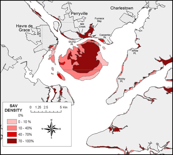
Once we were south of the shallowest spot, we moved back east so we could cross the Flats from the east to the west near the widest point, a distance of about 7 miles. The type and density of vegetation changes many times as one moves across the gigantic Flats bed. Against the eastern shore, halfway between White Point and Rocky Point, a dense bed of wild celery, water stargrass and milfoil extends several hundred yards from shore where two years ago there was only sparse milfoil. From the deepwater edge of this SAV bed up to shore the water is fairly clear, with the bottom visible at 3’. As you move west and the water depth increases to below 6’ (mlw), the grass disappears and the water becomes more and more turbid, with a Secchi depth of 18” to 2’. At a distance of 1.05 miles from the eastern shore (N 39 30.123’ W 76 00.537’), as the depth changes from 6’ to 5’, the first clumps of milfoil begin to appear- becoming more and more dense. As the depth drops from 5’ to 4’, clumps of wild celery and water stargrass appear, growing more and more dense until they form a solid mass of 75-100% cover that continues for several miles. Inside this dense central bed, the water is very clear. Secchi depths range from 4-5’, and the bottom is visible everywhere except in the many ditches that cross the Flats.
In some locations, particularly in areas far from the ditches where water movement is minimal, dark filamentous algae covers everything. These patches of algae are quite large in some spots, covering several acres so densely that no SAV is visible. I imagine that if color photographs of the Flats were taken right now, these algae-covered patches would stand out quite distinctly from the lighter colors of the SAV. We have seen this on the Flats before, and it seems to appear and disappear fairly randomly and to not cause great damage except in localized areas. While numerous patches of algae were scattered through the Flats, each patch was surrounded by healthy SAV. With miles of good SAV, it is difficult to be too concerned (although we certainly want to keep our eyes on it).
Great beds of SAV absolutely covered the main Flats bed, with wild celery, water stargrass, and milfoil being by far the dominant species. We also observed coontail, spiny naiad, slender pondweed, and hydrilla in the area, but at much lower densities. We doubled back as we approached the deep water shipping channel on the west side of the Flats, and headed south towards Turkey Point. The southern side of the Flats bed was very similar to the central part of the bed except that plant density is reduced and the water is far more turbid. This turbidity seems to always be present on the south side of the Flats, even when the middle Flats have more than 10’ of visibility as we saw last summer. Starting at Turkey Point and moving north, the vegetation along the eastern shore seemed to be more or less continuous all the way up to White Point and into the Northeast River.
From White Point, we went around Carpenter Point to look at Furnace Bay. Looking in from Stump Point, Furnace Bay appeared to be 100% vegetated with hydrilla- with vegetation visible on the surface despite being several hours away from low tide. Vegetation was visible far back in Mill Creek and as far as we could see into Furnace Bay itself. Approaching the bed, far from shore, milfoil clumps were scattered throughout the 5’ depth. As the boat came into the bed, we saw that near the mouth there was actually very little hydrilla. The bed was mostly wild celery and water stargrass, with some coontail, spiny naiad, and hydrilla in patches. It was incredibly dense, and bare sediment could be seen in very few spots. The water inside this bed was extremely clear. As we penetrated deeper into the bed, far back into Mill Creek, hydrilla became the dominant species- forming a thick mat that reached to within a foot of the surface. We moved slowly through the grass beds all around this area, watching feeding waterfowl, massive schools of minnows, big largemouth bass, and all the things one grows accustomed to seeing in SAV beds. It was a great way to end the day.
In summary, I think that the Flats SAV beds didn’t suffer greatly from the rainfall events of late June and early July of this year. With the exception of the loss of density in the northernmost portion of the bed, every location I visited looked as good or better than in 2005. Capt. Mike reported that the water has been clearing slowly but steadily ever since the storm, and he predicted that in a week or so the water would be extremely clear- similar to last year (unless we get another big storm). Developmentally, the water stargrass has begun to flower in many areas, and we even saw a few wild celery flowers reaching the surface.