Print This Page
|
Print This Page |
Heavy Rains and Run-off Lower Salinities and Restrict Water Clarity in the Chesapeake Bay
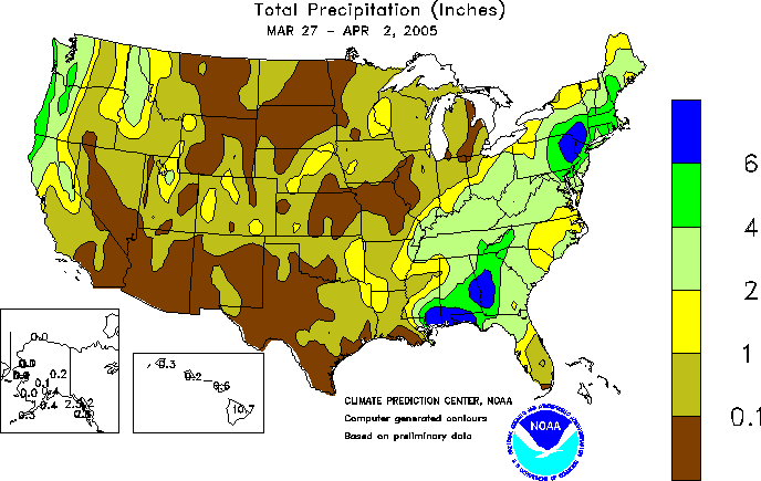
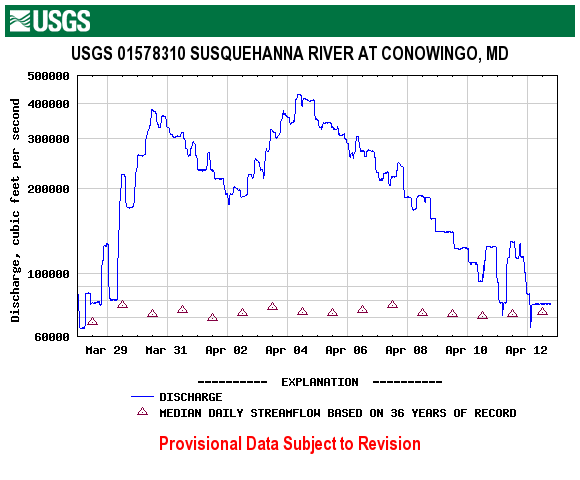
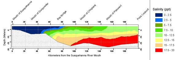
Heavy rains in late-March and early-April 2005 have caused localized areas of flooding in the upper Chesapeake Bay watershed, particularly in areas surrounding the northern branch of the Susquehanna River (Figure 1). Streamflow measurements collected at Conowingo Dam, MD showed that Susquehanna River discharges of 400,000 (cubic ft / cm) were observed, which is approximately 3 times greater than the 36-year median for this time period (Figure 2). Put into context, these flows were a little less than half of those seen during Hurricane Agnes on June 23, 1972. Freshwater (0 ppt) extended southward on the Bay’s surface past the Bay Bridge (Figure 3). This region is typically in the 6 – 8 ppt range in April.
Figure 1. - Weekly Precipitation provide by NOAA
|
Figure 2. - Susquehanna River Discharge at Conowingo Dam, provided by USGS
|
Figure 3. - Interpolated vertical profile map of April 4-6 main-Bay center channel salinity data, derived from Maryland DNR water quality data.
|
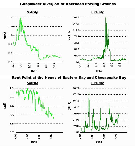
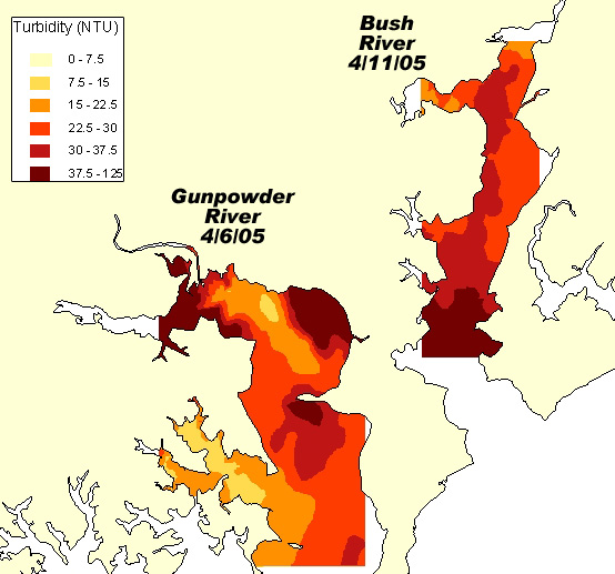
Many local creeks and streams appeared muddy brown as a result of the increased sediment loads and freshwater run-off caused by the heavy rains. Several of DNR’s real-time and near-time autonomous monitors captured these rapid changes in salinity and turbidity throughout the Chesapeake Bay (Figure 4). Water quality mapping cruises in the Bush and Gunpowder Rivers also detected elevated turbidity levels (Figure 5). Satellite imagery captured plumes of turbid water flowing down the major tributaries and upper Bay (Figure 6).
Figure 4. - Continuous Monitoring salinity and turbidity data taken from Eyes on the Bay.
|
Figure 5. - Spatially interpolated surface turbidity data from Water Quality Mapping (Dataflow) Cruises
|
Figure 6. - NASA MODIS TERRA satellite image from April 10, 2005. Current and archived satellite images are available at the Eyes in the Sky section of the Eyes on the Bay website
|
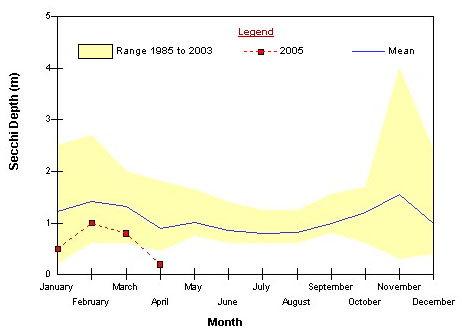
It is not certain at this time what impact the turbid waters will have on the Bay’s living resources, specifically bay grasses. The turbid waters have high concentrations of total suspended solids (TSS) that allow less light to reach the bay grasses, which need light to survive. Typically, turbidity values greater than 15 NTU are detrimental to bay grasses. Many of DNR’s autonomous monitors detected turbidity spikes three times greater than this threshold, with some areas peaking at 300 NTU. Water quality mapping found that most of the Bush and Gunpowder Rivers had turbidities greater than 15 NTU, and ranging up to 125 NTU. The Upper Bay, Choptank River and lower Potomac River experienced record low water clarity in early April due to the increases in turbidity (Figure 7). The turbid waters and subsequent low clarity correspond with the beginning of the bay grass growing period. This timing is critical since any inhibition during the onset of bay grass growth could lead to decreases in bay grass coverage in the Bay. However, the onset of this year’s bay grass growing season has been delayed because of a late warming trend in water temperatures. Many of the Bay’s grasses have not yet started to grow since water temperatures are below optimal levels for growth. It appears that the recent rain events and subsequent declines in water clarity should not affect bay grass survival at this time. However, if the poor water clarity persists, or if the Chesapeake Bay watershed receives heavy precipitation, bay grasses may be negatively impacted in the next few weeks.
Figure 7. - Fixed Station Secchi Depth Data from Station CB3.3 at the Chesapeake Bay Bridge showing record low water clarity in April 2005.
|