Skip to Main Content

Eyes on Deep Creek Lake

deep creek lake
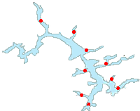
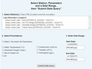
Maryland Department of Natural Resources has been monitoring water quality at Deep Creek Lake since 2009. The interactive map below displays long term mainstem and cove stations in Deep Creek Lake where we have collected water quality data since the program's inception in 2009. Below the map you will also find links to background information, water quality data downloads, reports, and newsletters.

Other MD DNR Deep Creek Lake Resources:

  • Filter Stations: check/uncheck the boxes for each water quality data type to turn data points on/off
  • Show Legend: mouseover this menu to display the legend for the station markers
  • Station markers: click to view station details, and link to data and charts
  • Zoom/Pan: zoom in & out using your mouse scroll button; click & drag to move the map around (mobile: pinch to zoom, touch & drag to move map)

For full-screen map view click here
For full functionality we suggest using Google Chrome or Mozilla Firefox.
Show Legend
Deep Creek Station Legend
blue circle Mainstem Lake Stations
Cove Stations
Change Year
Select Another Year
for Map Display:

Filter Stations

Please wait while the map loads...


Deep Creek Lake Water Quality Monitoring Programs:

Sampling through the ice

Mainstem Lake Monitoring

Water quality profiles and water samples collected at 4 mainstem lake stations from 2009-present, during select months (March/April, May, June, July, August, September, November/December).
Spatial Water Quality Data Map

Cove Sampling

Water quality profiles collected at 7-10 lake embayment stations near-monthly from 2009-present. These shallower areas represent the nearshore environment where most water quality concerns are found.
Tributary sampling

Tributary Sampling

Beginning in 1980, monthly 'base flow' samples, as well as storm event samples, have been collected from the Cherry Creek site to determine nutrient and sediment loadings.

Aquatic Vegetation Monitoring

The types, distribution, and abundance of aquatic vegetation types have been surveyed at various locations within Deep Creek Lake since 2010.

Deep Creek Reports:

Water Quality Reports:

Submerged Aquatic Vegetation Reports:

hydrilla removal    • 2016 Report
   • 2015 Report
   • 2014 Report    • 2013 Report    • 2012 Report    • 2011 Report

Deep Creek Newsletters:


* You can also search Eyes on the Bay's publications database, just choose 'Deep Creek Lake' as your 'Region' of interest.

About Deep Creek Lake:

Deep Creek Lake is the largest reservoir completely within the Maryland's boundaries. Like all Maryland lakes, Deep Creek Lake is manmade, and was created in 1925 by impounding Deep Creek with an earthen dam to provide a water source for a nearby hydroelectric generating station on the banks of the Youghiogheny River.

After Maryland purchased the lake property in 2000, Department of Natural Resources (DNR) managers needed information to support decisions regarding lake management activities. Initially, 8 mainstem lake and 9 tributary cove monitoring sites were sampled.

Beginning in July 2014, the mainstem lake sampling effort was reduced to four sites. In July 2016, the previously established cove sites were discontinued and effort was redirected to increasing the number of cove sites monitored for physical water quality parameters...   READ MORE >>

wake of DNR research vessel

Deep Creek Water Quality Data:

Download Deep Creek Lake water quality data as a .csv file from Deep Creek Lake for your desired station(s), parameters, and date range using our data query tool on our Deep Creek Lake Data Downloads page. Data for other Deep Creek Lake monitoring programs and stations will be added soon.

data download

In-situ parameters measured at each station:

  • Conductivity
  • pH
  • Water temperature
  • Turbidity
  • Fluorescence
  • Secchi depth

Additionally, surface and bottom water quality samples are collected at each of the mainstem stations.