Skip to Main Content

Eyes on the Bay Home

Thank you for visiting Eyes on the Bay, your home for Maryland tidal water quality data and information. We hope that our data search and download pages will be useful tools. The map below displays all the stations where we collect water quality data, as well as partner stations.

  • Filter Stations: check/uncheck the boxes for each water quality data type to turn data points on/off
  • Change Year: use this dropdown to view what stations were sampled in different years
  • Show Legend: mouseover this menu to display the legend for the station markers
  • Station markers: click to view station details, and link to data and charts
  • Zoom/Pan: zoom in & out using your mouse scroll button; click & drag to move the map around (mobile: pinch to zoom, touch & drag to move map)

For full-screen map view click here
For full functionality we suggest using Google Chrome or Mozilla Firefox.
Show Legend
Station Legend
Long-Term Fixed Station
Dataflow / Water Quality Mapping Segment
Continuous Monitoring Station with Real-time Telemetry
Continuous Monitoring Station without Telemetry
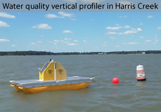
purple dot Vertical Profiler Continuous Monitoring Station
Continuous Monitoring Station not Currently Active
Partner Sites
National Data Buoy Center or NOAA buoys
Tide Prediction Sites
(Click for current weather/water conditions)
More info on:
"Our Monitoring Explained"
Change Year
Select Another Year
for Map Display:
Filter Stations

Please wait while the map loads...